
Description
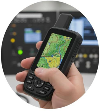
The GPS D&V CH-73956 is a rugged, high-performance device built for accurate navigation in demanding environments. Featuring a 3″ color transflective touchscreen, 16 GB of internal memory expandable via microSD, up to 840 hours of battery life in low-power mode, and IPX7 waterproof rating, it ensures reliability under extreme conditions. Compatible with multiple satellite systems (GPS, GLONASS, GALILEO, QZSS, BEIDOU), it comes with preloaded maps, automatic route creation, and advanced sensors such as a 3-axis compass and barometric altimeter.
| REFERENCE | Dimensions of the unit (Width/Height/Depth) 6.2 x 16.3 x 3.5 cm
(2.5″ x 6.4″ x 1.4″) +/- 0.2 cm in all the Touchscreen directions Size of the screen (Width/Height) 3.8 x 6.3 cm (1.5″ W x 2.5″ H) 7.6 cm diagonally (3″) +/- 0.2 cm in all directions Screen resolution (W/H) 240 x 400 pixels Guy of screen TFT in color transflective Weight up to 230 grams with batteries MIL-STD-810 YEAH (temperature, blows, water) |
| BATTERY | Battery NiMH rechargeable (included)
Autonomy of battery Until 180 hours in mode default Up to 840 hours in low power mode Classification of endurance to the water IPX7 Memory/history minimum 16 GB High Sensitivity Receiver USB-C Interface |
| MAPS AND MEMORY | Maps pre-installed: mapping according to need Possibility of adding maps
Map base Creation automatic of Routes (Turn to Turn in road) Map Segments: 15,000 Includes accidents hydrographic with a high level of detail (lines of coast, lines of coast of lakes and rivers, swamps and streams perennial and seasonal) Includes searches of points of interest sample parks nationals, regional and local, forests and natural landscapes Storage and ability of burden Card microSD of until 32 GB Presentation of images areas detailed Until 10,000 points of reference saved by he operator Routes 250, 250 points by route, 50 points of routes automatic at least Tracks 20,000 points, 250 tracks saved, 300 activities of exercise saved as a minimum Routes 250, 200 points of journey by journey as minimum |
| SENSORS | Compass with three axes with inclination Compensated Barometric Altimeter: Yes Receiver of high Compass
Sensitivity GPS (in movement) Frequency Multiband |
| CONNECTION TO SATELLITES | GPS, GLONASS, GALILEO, QZSS, BEIDOU |
| FUNCTIONS DAILY SMARTS | Screens of clock, fields of data, widgets and applications Downloadable Smart Notifications on your handheld device
Forecast of the time Smart Active Time Mode to Distance for VIRB |
| FUNCTIONS OF FOLLOW-UP AND SECURITY | Function that allows share the location and the route of a activity in real time |
| FUNCTIONS LEISURE TO THE AIR FREE | Navigation spot to point Area Calculation Astronomical Information
Compatible with the maps personalized with by it less 500 mosaics custom map Flashlight Image Viewer Led of beacon |
| FUNCTIONS OF COMMUNICATION | Two-way communication |
| CONNECTIVITY | Connectivity minimum Wi-Fi, Bluetooth |
Reviews
There are no reviews yet.